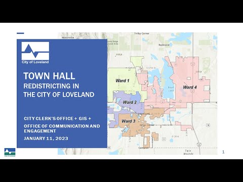
Redistricting

Share on Facebook Share on Twitter Share on Linkedin Email this link

As the City works to update Loveland’s ward boundaries, some residents may find themselves in a different ward for the 2023 election season. This process is what’s known as redistricting, and these efforts are necessary for several reasons – but most importantly, it ensures that wards remain as equal in population as possible and allows the City to coordinate with Larimer County on local elections, making it easier for residents to vote. Redistricting is an as-needed process that usually happens after new population data is calculated through the U.S. Census Bureau.

A brief history

Loveland’s City Charter established four wards to divide the City in 1966, and nine other boundary adjustments have been made since then, with the last adjustment in 2017. In 2021, both the State of Colorado and Larimer County went through similar efforts and established new boundaries for state congressional and legislative districts as well as county precincts. As Loveland continues to grow and as boundaries expand, population data shows that Loveland’s current ward counts are off-balance - with several wards having a population difference of more than 10% – more than twice the allowed amount.

The redistricting process

The redistricting process is driven by the City Clerk’s Office with support from the Geographic Information Systems (GIS) team and is guided by the City Charter and the Municipal Code. When establishing new ward boundaries, the City needs to ensure that:

  1. Currently seated City Councilors remain in their same ward;
  2. There is no more than a 5% deviation in population between wards;
  3. Wards match County precincts with only one ward in each precinct;
  4. Wards be as compact as possible without splits;
  5. Wards align with natural breaks (such as roadways, neighborhoods, lakes/rivers and railroads) as much as possible.

City staff have taken necessary steps to create four possible options that meet the above criteria.

Share your voice in the process

Now through January 31, 2023, residents are invited to provide comments on the proposed options ahead of the 2023 election season. Additional information can be found in the sidebar to the right (or below on mobile devices).

Share on Facebook Share on Twitter Share on Linkedin Email this link

Locate Your Current Ward

over 1 year

Not sure which Ward you currently reside in? Use this map to find out!

Once you've found your ward, use the "Plus" icon to the left to drop a pin and let us know you stopped by.


City Council Ward Legend
Ward 1
Richard Ball
Patrick McFall
Ward 2
Andrea Samson
Dana Foley
Ward 3
Steve Olson
John Fogle
Ward 4
Jon Mallo
Don Overcash


Map Legend

Downtown Development Authority Boundaries
CLOSED: This map consultation has concluded.
Share on Facebook Share on Twitter Share on Linkedin Email this link

Leave feedback on Option 1

over 1 year

Option 1 keeps a portion of Downtown areas (based on Downtown Development Authority boundaries) in all wards and has a population deviation of 2%.

In this option, boundaries are distributed based on majority, councilor and a shape that best fits a contiguous compact principle. It also ensures all wards have a portion of Downtown.

Use the "Plus" icon to the left to drop a pin and let us know the things you like and don't like about this option.

Compare Option 1 with Options 2, 3 and 4 →


Pros of Option 1:

  • Gives all wards a portion of Downtown/DDA area.
  • Provides the most contiguity.
  • Positions things so future moves have a more natural progression.
  • Moves less people to a new ward when compared to Option 2.

Cons of Option 1:

  • Not the most balanced option, but very close.

City Council Ward Legend
Ward 1
Richard Ball
Patrick McFall
Ward 2
Andrea Samson
Dana Foley
Ward 3
Steve Olson
John Fogle
Ward 4
Jon Mallo
Don Overcash


Map Legend

Downtown Development Authority Boundaries
CLOSED: This map consultation has concluded.
Share on Facebook Share on Twitter Share on Linkedin Email this link

Leave feedback on Option 2

over 1 year

Option 2 has the most balanced wards but eliminates Downtown areas from Ward 2 and Ward 4 and has a population deviation of 2%.

In this option, boundaries are distributed based on majority, councilor and a shape that best fits a contiguous compact principle. It also provides for balanced wards but eliminates Downtown area for Ward 2 and Ward 4.

Use the "Plus" icon to the left to drop a pin and let us know the things you like and don't like about this option.

Compare Option 2 with Options 1, 3 and 4 →


Pros of Option 2:

  • Most balanced option.
  • Council noted that keeping Downtown/DDA areas in all Wards did not need to be a consideration.

Cons of Option 2:

  • Wards 2 and 4 will not have a portion of downtown/DDA area.
  • Lacks some contiguity and stretches Ward 4 towards the southeast.
  • Does not represent the natural progression of growth and may require more significant changes for Wards 3 and 4 in the future.

City Council Ward Legend
Ward 1
Richard Ball
Patrick McFall
Ward 2
Andrea Samson
Dana Foley
Ward 3
Steve Olson
John Fogle
Ward 4
Jon Mallo
Don Overcash


Map Legend

Downtown Development Authority Boundaries
CLOSED: This map consultation has concluded.
Share on Facebook Share on Twitter Share on Linkedin Email this link

Leave feedback on Option 3

over 1 year

Option 3 was created using feedback from City Council to keep the old Hewlett-Packard neighborhood in its existing ward and has a population deviation of 2%.

In this option, boundaries are distributed based on majority, councilor and a shape that best fits a contiguous compact principle.

Use the "Plus" icon to the left to drop a pin and let us know the things you like and don't like about this option.

Compare Option 3 with Options 1, 2 and 4 →


Pros of Option 3:

  • Gives all wards a portion of Downtown/DDA area.
  • Provides good contiguity.
  • Positions things so future moves have a more natural progression.
  • Moves less people to a new ward when compared to all other options.
  • Keeps the old Hewlett-Packard neighborhood together in its existing ward.

Cons of Option 3:

  • Not the most balanced option; but very close

City Council Ward Legend
Ward 1
Richard Ball
Patrick McFall
Ward 2
Andrea Samson
Dana Foley
Ward 3
Steve Olson
John Fogle
Ward 4
Jon Mallo
Don Overcash


Map Legend

Downtown Development Authority Boundaries
CLOSED: This map consultation has concluded.
Share on Facebook Share on Twitter Share on Linkedin Email this link

Leave feedback on Option 4

over 1 year

Option 4 was created to account for growth in Ward 1 and Ward 4 based on current development activity and has a population deviation of 4%.

Use the "Plus" icon to the left to drop a pin and let us know the things you like and don't like about this option.

Compare Option 4 with Options 1, 2 and 3 →


Pros of Option 4:

  • Takes into account the growth that will occur in Wards 1 and 4 due to current development activity.
  • Helps reduce the need to redistrict earlier than might otherwise be needed.

Cons of Option 4:

  • Highest deviation amongst Wards – 4%.
  • Moves highest number of people to new Ward – 27.4% disruption rate.

City Council Ward Legend
Ward 1
Richard Ball
Patrick McFall
Ward 2
Andrea Samson
Dana Foley
Ward 3
Steve Olson
John Fogle
Ward 4
Jon Mallo
Don Overcash


Map Legend

Downtown Development Authority Boundaries
CLOSED: This map consultation has concluded.
Share on Facebook Share on Twitter Share on Linkedin Email this link

NEW: Leave feedback on Option 5

about 1 year

Option 5 was created by Marie Davis-Green with the following information:

All of Garfield Ave. "South" of Hwy #34 should be included with the Downtown District. There is not one option that includes it. This is a main corridor leading into the downtown area with many historic homes that should be included as part of the historic downtown area. Historic homes from 1887, especially the block on Garfield from 10th to 12th street, has always been part of Ward 2 and included as part of the downtown historic district! Some of these homes have a lot of history attached to them.

Use the "Plus" icon to the left to drop a pin and let us know the things you like and don't like about this option.


City Council Ward Legend
Ward 1
Richard Ball
Patrick McFall
Ward 2
Andrea Samson
Dana Foley
Ward 3
Steve Olson
John Fogle
Ward 4
Jon Mallo
Don Overcash


Map Legend

Downtown Development Authority Boundaries
CLOSED: This map consultation has concluded.
Share on Facebook Share on Twitter Share on Linkedin Email this link

View Larimer County Voter Precincts

over 1 year

Looking to create your own map for consideration or just curious to see which Larimer County voter precinct you live in? Check out this map! A few notes:

  • The shaded gray areas represent Loveland's City Limits.
  • The solid black boundaries represent Larimer County's voter precincts that have been clipped to the bounds of Loveland's City Limits.
  • Click on the map to see the population of Loveland residents living within each precinct (slightly adjusted from 2020 U.S. Census data to account for growth) and the corresponding precinct number.
  • As some boundaries appear very close, we encourage you to use the zoom in/out function on the map to get a better look.

Download this and other helpful data.


Map Legend

Loveland City Limits

Larimer County Voter Precincts*

Downtown Development Authority Boundaries


Precincts Locked Due
to Councilor Residence
Ward 1
Richard Ball
Patrick McFall
Ward 2
Andrea Samson
Dana Foley
Ward 3
Steve Olson
John Fogle
Ward 4
Jon Mallo
Don Overcash


*For ease of representation, please note that Larimer County voter precincts have been clipped to only include areas that overlap with Loveland's City Limits. View complete Larimer County GIS data on their website.

CLOSED: This map consultation has concluded.