
FAQs
General
HIP Streets is a project that has been discussed for many years. What triggered the launch of the 4th Street portion of the project?
The existing waterline, along 4th Street is over 100-years old. The waterline has far surpassed its useful life and it has mineral buildup within the line (called tuberculation), and water flow issues have also been cited. The waterline needs to be replaced to meet water quality standards and provide adequate water flow.
How is the project being funded?
For this project, there are two components: the under-surface utility work funded through enterprise funds (approximately $8.4M), and the HIP Streets element—which focuses on the physical space and aesthetics of the finished project—that will be funded by our partners at the Loveland Downtown Development Authority (DDA) and through a Stormwater Revenue Bond (Approximately $10.8M). City of Loveland staff are also looking into potential grants which will also help offset project costs.
Final project costs will be determined based upon continually updated design. We anticipate design to be finalized in 2024 with expenses budgeted and spent from 2023 to 2026.
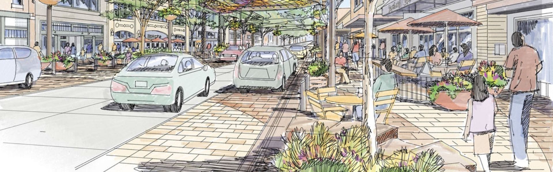
What are some of the major street and sidewalk changes that have been considered for the corridor?
The HIP Streets plan, which began in 2009 and was updated in 2017, has always visualized enhanced pedestrian-space with wider sidewalks. Wider sidewalks allow businesses to potentially use exterior space for patios or retail, it expands the width of the walkway, improves ADA conditions, and allows an amenity zone for additional plantings, seating and artwork. To allow for the wider sidewalks the existing roadway width will be maintained and parking will be converted to parallel parking for the five-blocks along 4th Street.
Input collected during the creation of the City of Loveland’s Downtown Parking Study that was adopted in 2018 and updated in 2022, supported the switch to a parallel parking alternative. To achieve the desired enhanced pedestrian space, it isn't possible to maintain diagonal parking.
Additionally, the City recently approved the addition of parking enforcement in downtown, which will monitor designated spaces to ensure vehicle turn-over throughout the corridor.
An all-pedestrian, vehicle-free corridor has not been considered. Maintaining this street as a through-street corridor is desired throughout the downtown.
What is happening to the plaza at the former Mr. Neats?
In November 2023, the City of Loveland sold the Mr. Neats plaza property. This property will not be redeveloped as part of the HIP Streets 4th Street project.
What is the plan for the pocket park at 4th and Lincoln?
The DDA and City of Loveland Parks Department are working with a designer on potential concepts for the Pocket Park on 4th Street and Lincoln Ave. Concepts are not defined at this time, but ideally a concept will be completed simultaneously with construction on 4th Street.
How will artwork, both existing and new, be incorporated into the final project?
The team is working with staff from the City’s Cultural Services Department and the Visual Arts Commission to integrate artwork into the HIP Streets 4th Street design. During construction, existing art will be removed by the City and either temporarily stored or relocated within Loveland at the discretion of the Visual Arts Commission.
Urban design elements and City public art elements will be included in the design. The City’s Visual Arts Commission will oversee and administer the commissioning of a placemaking art for the HIP Streets 4th Street corridor. The Visual Arts Commission will also consider adding up to three members of the HIP Street design team and three Loveland residents to serve with the commissioners as artwork jurors on this public art project committee.
As part of these improvements, the design will also feature four art locations on each block, for a total of 20 art pieces along the five-block corridor. Art pieces may be permanent or temporary installations of two or three-dimensional media at the discretion of the Visual Arts Commission.
More information about the Visual Arts Commission is posted to the City's website.
Parking
What do you anticipate as the impact to parking once this project is complete?
The current diagonal / angled parking will be converted to parallel parking along the five blocks on 4th Street between Garfield and Washington Ave. The design team is working on adjacent roadways within about one block of 4th Street to modify existing on-street parking and add more spaces. Some existing locations that are now parallel may become angled. Once complete, we anticipate approximately 30 to 40 new parking spaces will be added around the 4th Street corridor. This will enable a wider pedestrian corridor and provide a more consistent downtown parking experience.
As part of the design, we are looking to add one to two short-term/drop-off locations per block.
How many ADA parking spaces exist in the 4th Street corridor? When the project is complete, how many spaces can we expect?
Currently, there are ten ADA parking spaces on 4th Street in the project area. These spaces are not evenly distributed in the project area. Once the project is complete, we will continue to maintain ten ADA spaces, the difference is they will be evenly distributed throughout the corridor.
What are the municipal code requirements for ADA parking?
Loveland Municipal Code requires one ADA space for every 25 parking spaces for private developments to be code compliant. For projects in the right-of-way, there is no requirement for parking ratios. Along 4th Street, the design is anticipating one designated ADA space for every ten parking spaces within each two block span. The design is also considering additional ADA parking spaces on adjacent roadways.
Bike Access
Why are there no dedicated bike lanes in the proposed plan?
The width of the corridor, between buildings, is not wide enough to accommodate a dedicated bike lane. Bikes are intended to merge with traffic through sharrows along 4th Street. A sharrow is an area of road where bikes merge with vehicular traffic and share the road. In Colorado, motorists and bicyclists share the road and both have equal rights. CDOT has more information about bike and vehicle laws on its website.
Will bike parking be added along the corridor?
Yes, the project team intends to add bike parking as part of the project plan. These locations will be identified through future design iterations.