
Highway 287 Flood Mitigation Project
History
US Highway 287 is an alternative to the increasingly congested Interstate 25 corridor for entering Loveland, and it provides access to the city’s many recreational amenities along the Big Thompson River corridor.
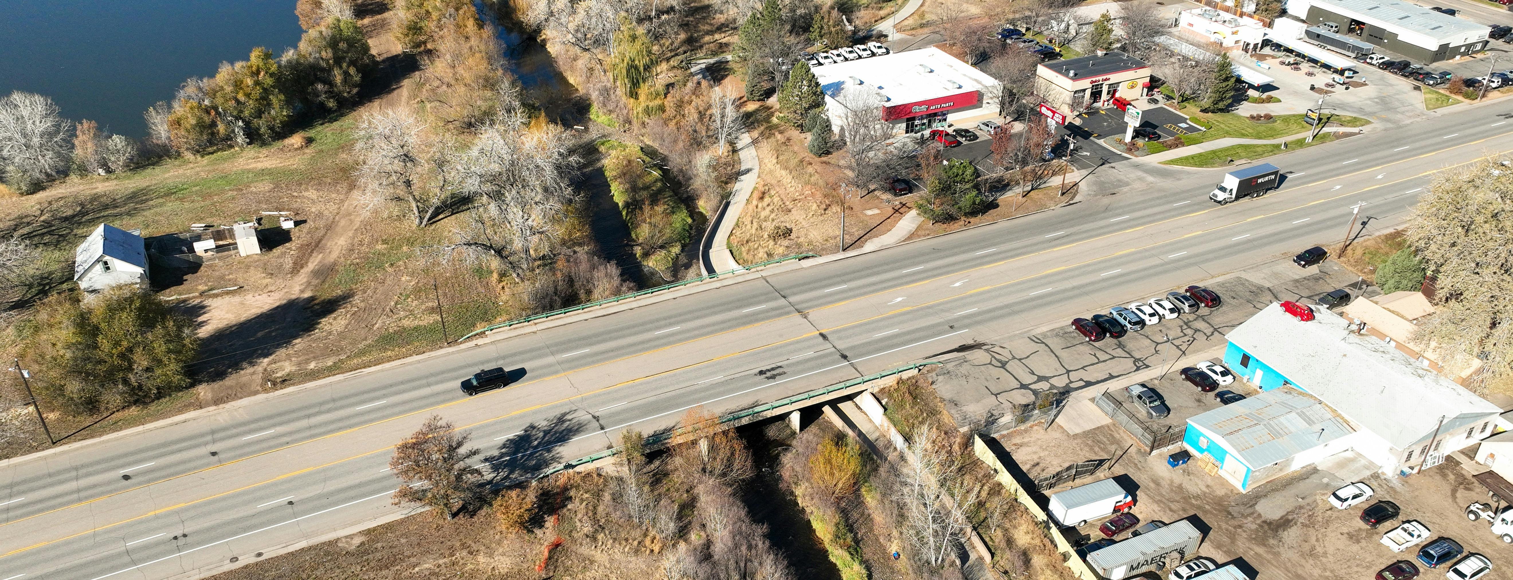
The Big Thompson River has sustained 13 damaging floods, the most recent in September 2013, resulting in significant damage to public infrastructure and private properties in Loveland. Of particular concern was the area of the Big Thompson near US 287 (Lincoln Avenue) with its vital north-south highway connection into the city, the Burlington Northern-Santa Fe Railroad tracks, two large community parks, the Loveland Fire Rescue Authority’s training facility and a dense cluster of buildings and businesses.
Excluding the cost for emergency response, the 2013 flood caused $9.9 million in damage to public infrastructure in this area. That’s over $18 million in today’s dollars. The US 287 bridge nearly failed from scour undermining the piers and north abutment, and the highway was closed for more than two weeks as the river overtopped the roadway. Many businesses were closed for months due to significant flood damage.
The need for more resiliency in this area following the 2013 flood led to the creation of the Big Thompson River Corridor Master Plan, which was adopted by City Council in June 2019. This plan identifies numerous projects and river maintenance activities to implement along the nine-mile stretch of the river through the Loveland area.
Along with these river corridor enhancements, the City of Loveland is improving the US 287 and State Highway (SH) 402 intersection and rebuilding the US 287 bridge over the Big Thompson River as part of the Highway 287 Flood Mitigation project.
Project Description
The Highway 287 Flood Mitigation project is a joint effort between the City of Loveland, the Colorado Department of Homeland Security and Emergency Management (DHSEM) the Federal Emergency Management Agency (FEMA) and the Colorado Department of Transportation (CDOT) to design flood mitigation measures for the Big Thompson River at Highway 287. This project will focus on the US 287 bridge, but the entire project area extends from Railroad Avenue on the west to about Saint Louis Avenue on the east. Along US 287, the project area extends about 1,000 feet to the north and south of the river.
The project has three main components: bridge replacement and retrofitting, stream restoration, and floodplain improvement. A primary goal is to increase community resiliency by removing as many properties as feasible from the 100-year floodplain and reducing flood risk to those structures that remain in the floodplain.
The US 287 and SH 402 Intersection Improvement project is a key component of the Highway 402 Corridor Plan that outlines the city’s plans for improvement, beautification and revitalization of the 4.2-mile SH 402 corridor from I-25 to S. Taft Avenue. This intersection improvement project will address traffic congestion, reduce safety concerns and support regional access. Its limits extend from the end of the US 287 bridge improvements to approximately 400 feet south of the intersection.
Project Scope
The Highway 287 Flood Mitigation project includes building a new US 287 bridge structure over the Big Thompson River. This new bridge will be about 4 feet higher than the existing structure and will include four through lanes, a center turn lane, bike lanes and a sidewalk. Other project elements include:
- Addressing access points throughout the project corridor to accommodate raising the bridge and highway about 4 feet to help prevent the river from overtopping the roadway.
- Creating a natural open space corridor by connecting the existing public natural areas and parks just upstream and downstream of the bridge.
- Reducing flood risk by increasing floodplain capacity adjacent to the river channel and using nature-based solutions (things such as planted vegetation or boulders).
- Improving opportunities for public interaction with the river through better access.
- Restoring natural areas and improving river health as best as possible.
- Creating a signature southern entrance into Loveland.
The US 287 and SH 402 Intersection Improvement project includes these elements:
- Widening and reconfiguring the intersection approaches to address safety concerns and improve travel times with dedicated turning movements.
- Partnering with adjacent stakeholders to provide right-of-way improvements and increase economic opportunity and redevelopment for SH 402.
- Improving pedestrian crossings, curb ramps and sidewalks to enhance safety and accessibility.
- See this conceptual exhibit of the project improvements.
Timeline of Highway 287 Flood Mitigation project
- 2023 – Design efforts began
- 2024 – Initial design information shared with community members
- 2025 – Design refinements and stakeholder coordination
- 2026 – Apply for BUILD grant and finalize design for the river corridor improvements
- 2027 – Finalize design for the US 287 bridge reconstruction project and lock in plans, specifications and cost estimates to solicit contractors
- 2027 – Tentative start of construction of river corridor improvements
- 2028 – Tentative start of construction of new US 287 bridge over the Big Thompson (pending funding)
Timeline of US 287 and SH 402 Intersection Improvement project
- 2026 – Preliminary design plans developed
- 2027 – Finalize design, secure right-of-way and begin construction of intersection improvements (pending funding)
- 2028 – Complete construction
Project Funding
The river corridor improvements, reconstruction of the US 287 bridge and improvements to the US 287 and SH 402 intersection will cost an estimated $50 million. To help cover the cost of these projects, the City of Loveland has submitted a BUILD grant application to the U.S. Department of Transportation. BUILD grant funds would also be used to improve the intersection of US 34 and US 287.
Stay Informed
To stay informed about this project, subscribe to our email list in the “Stay Informed” section.
-
FOR RELEASE: Highway 287 flood mitigation open house scheduled for July 9
Share FOR RELEASE: Highway 287 flood mitigation open house scheduled for July 9 on Facebook Share FOR RELEASE: Highway 287 flood mitigation open house scheduled for July 9 on Twitter Share FOR RELEASE: Highway 287 flood mitigation open house scheduled for July 9 on Linkedin Email FOR RELEASE: Highway 287 flood mitigation open house scheduled for July 9 link
The City of Loveland is taking a step toward protecting the community from floods with a plan to rebuild the Highway 287 bridge over the Big Thompson River and improvements of the adjacent river channel. Community members are invited to learn more about this project and ask questions during an open house on Tuesday, July 9, from 4 to 6 p.m. at the Fairgrounds Park Pavilion, 700 S. Railroad Ave.
“This is one of the city’s highest priority capital improvement projects and it will help protect community infrastructure and private properties that were heavily damaged in the 2013 flood,” said Stormwater Engineering Manager Chris Carlson.
The open house will feature displays, estimated construction timelines, phasing information, and opportunities for attendees to engage with City and contractor staff.
The Highway 287 Flood Mitigation project, which is currently in the design phase, will rebuild and raise the Highway 287 bridge about 4 feet and improve the Big Thompson River channel between Railroad and Saint Louis Avenues near Fairgrounds Park. In the process, the project team will address flood prevention resources for properties in the 100-year floodplain and recreation amenities improved with better access to the river for fishing and tubing.
For more information on this project or to ask questions for the project team, visit letstalkloveland.org/highway-287-flood-mitigation.
About
The Highway 287 Flood Mitigation project is a joint effort between the City of Loveland, the Colorado Department of Homeland Security and Emergency Management (DHSEM) the Federal Emergency Management Agency (FEMA) and the Colorado Department of Transportation (CDOT) to design flood mitigation measures for the Big Thompson River at Highway 287. This project will focus on the Highway 287 bridge, but the entire project area extends from Railroad Avenue on the west to about Saint Louis Avenue on the east. Along Highway 287, the project area extends about 1,000 feet to the north and south of the river. The project has three main components: bridge replacement and retrofitting, stream restoration and floodplain improvement. A primary goal is to increase community resiliency by removing as many properties as feasible from the 100-year floodplain and reducing flood risk to those structures that remain in the floodplain.
Project Funding
The project design will cost an estimated $2.6 million with about 90% of the costs being covered by a flood mitigation grant from the Federal Emergency Management Agency. The remaining 10% of the funds are coming from the increased stormwater fees residents started paying on their utility bills in September 2022. An estimate of construction costs will be developed when the design work is complete. Construction is tentatively scheduled to begin in 2026.
CONTACT: Illianna Milldrum, Communication and Engagement Specialist, 970-962-2608, Illianna.Milldrum@cityofloveland.org
Videos
-
 Sept. 12, 2013, was a day that changed the trajectory of the Loveland community. Steady rain continued for a week, and flood water inundated more than three square miles of Loveland, covering roads and closing all bridges over the river.
Who's Listening
-
CC
Phone 970-962-2774 Email Chris.Carlson@cityofloveland.org -

Phone 970-962-2547 Email justin.piles@cityofloveland.org -

Phone 303-268-0224 Email arogers@mullereng.com -

Phone 970-962-2608 Email Illianna.Milldrum@cityofloveland.org
